District Profile
a) Establishment : 28th MAY 1983
b) Geographical Location :
Latitude : 230 40’
Longitude : 840 40’ To 840 50’
c) Geographical Boundry :
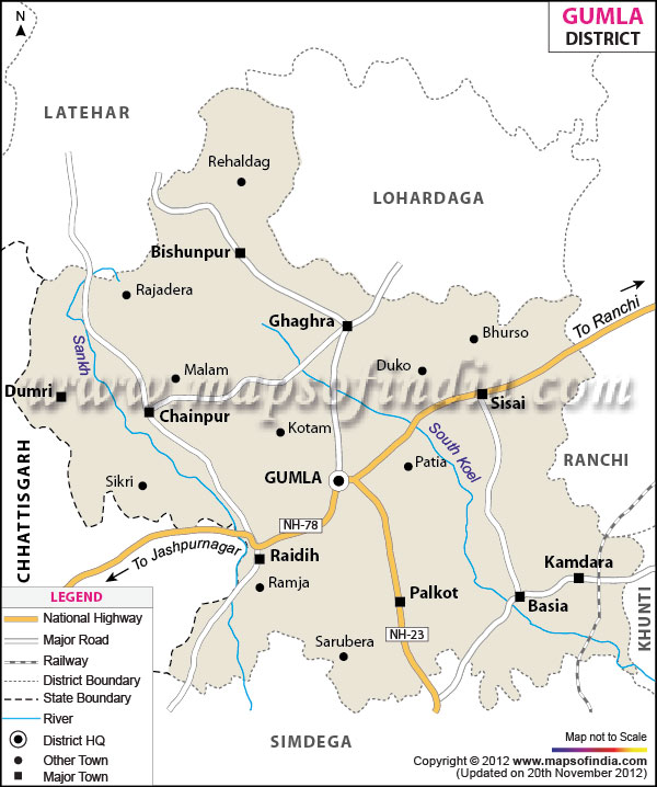
North : Lohardaga
South : Simdega
East : Ranchi
West : Chhatisgarh
d) Total Geographical Area :
529546.15 hectare
5321 Sq. Km.
e) Soil : Red Laterite & Alluvium Sediments (Near river bed)
f) Climate :
Average annual rainfall : 1100 mm
Temperature : 5 – 450 C
Relative Humidity : 30 - 90%
g) Important Rivers : Koel, Sankh and North Koel
h) Administrative Units :
No. of Sub-Division : 03
No. of Blocks : 12
- Gumla
- Raidih
- Chainpur
- Dumri
- Palkot
- Basia
- Kamdara
- Sisai
- Bharno
- Ghaghra
- Bishunpur
- Albert Ekka Jari
No. of Village : 948
No. of Panchayats : 159 + 1 Municipality
Literacy Percentage : 65.73 % (According to 2011 census)
i) Population (According to 2011 Census) :
| Total | 10,25,213 |
|---|---|
| Male | 5,14,390 |
| Female | 5,10,823 |
| Rural Population | 960132 (93.65%) |
| Urban Population | 39761 (3.87%) |
| ST | 706754 (68.94%) |
| SC | 32429 (3.17%) |
| Other | 286000 (27.89%) |
j) Socio-Economic Status :
| Farmers | 321272 (65.90%) |
|---|---|
| Agricultural Laborers | 97918 (20%) |
| Home Industries Labour | 3.42% |
| Other Workers | 55547 (11.39%) |
| BPL | 74.75% |
k) Land Utilisation Pattern :
| Geographical Area | 529546.15 ha. |
|---|---|
| Total Forest Area | 135600 ha (Wild Life Sanctuaries 183.18 Sq. Km ) |
| Cultivable Area | 329600 ha |
| Permanent Pasture | 2204 ha |
| Net Cultivated Area | 259419.1 ha |
| Net Irrigated Area | 67760 ha |
| Cultivable waste land | 31598 ha |
DON LAND
- Done – I - 29044.47 ha
- Done – II - 33664.8 ha
- Done – III – 30986.60 ha
TAR LAND
- Tar – I - 13134 ha
- Tar – II - 82506.59 ha
- Tar – III - 70083.25 ha
l) Area Covered Under Different Crops :
(As per data of District Agriculture Department, Gumla )
| Kharif (ha) | |
|---|---|
| Paddy | 188000 |
| Maize | 7340 |
| Pulses | 24762 |
| Oil Seeds | 8419 |
| Coarse Cereals | 1790 |
| Rabi (ha) | |
| Wheat | 12000 |
| Rabi Maize | 2000 |
| Gram | 12600 |
| Lentil | 5500 |
| Pea | 3200 |
| Mustard | 15300 |
| Linseed | 2800 |
| Safflower | 227 |
| Sun-Flower | 100 |
* Source : District Agriculture Department, Gumla (Targeted area for 2013&14 & 2015-16)
Agro-climatic Zone & Major Agro Ecological Situations
| S.N. | Agro-climatic Zone | Characteristics |
|---|---|---|
| 1 | Zone V | The soil of plateau is nutritionally poor & organic matter rapidly declining due to deforestation, leaching & soil erosion. Hence high degree of soil management and soil husbandry have become imperative for intensive cultivation in the existing soil of the plateau the soil of the district is Red laterite to Sandy Clay & Clay loam. The farming situation of the district is rainfed the cropping pattern is mainly monocropping & kharif based. |
Agro Ecological Situation
| S.N. | Agro Ecological Situation | Characteristics |
|---|---|---|
| 1 | South Western Plateau | South Western plateau is characterized by hot sub humid eco-region with red loamy soil. Summer season is generally hot and winter is cold. The soil type varied from red laterite to sandy clay and clay loam with an undulating topography and least irrigation facilities. |
Soil Type/s
| S.N. | Soil Type | Characteristics | Area in ha |
|---|---|---|---|
| 1 | Red laterite to sandy clay & clay loam | The soil is universally poor in N & K due to high excessive leaching. They have high P fixation capacity due to the presence of Kaolinitic along with sesquioxides. Hence high degree of soil management and soil husbandry have become imperative for intensive cultivation in the existing soil of the plateau. |
80% of the total geographical area (531396.13 ha) |
AES Map of Gumla
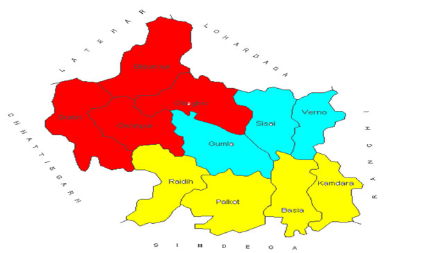
- AES [I] High altitude, Sandy loam soil, Rainfed undulated land & dense forest (Bishunpur, Ghagra, Chainpur, Dumri Block ).
- AES [II] Loamy sand soil, Rainfed, undulated land (Bharno, Sisai, Gumla Block).
- AES [III] Sandy loam, Rainfed, Moderately undulated land & Forest area (Raidih, Palkot, Basia, Kamdara Block).